
Background & Basic Data
unnamed
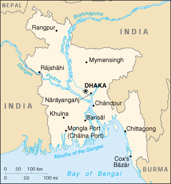
BANGLADESH
Official Name : The People’s Republic of Bangladesh
Political System : Parliamentary Democracy
Capital Name : Dhaka
Time Zone : GMT +6 Hours
Location : between 20°34′ to 26°38′ north latitude and 88°01′ to 92°41′ east longitude
Boundary
Northern/Western Border : Shares a long border with India, primarily with the states of West Bengal, Assam, and Meghalaya
Eastern Border : Borders Indian states of Tripura and Mizoram
Southeast Border : Shares a border with Myanmar
Southern Border : Opens into the Bay of Bengal, determining its maritime territory
Geographic Context : The country is largely a deltaic plain created by the Ganges, Brahmaputra and Meghna rivers
Area : 56,977 sq miles or 147,570 sq km
Territorial Water : Beyond the 12 NM territorial sea, Bangladesh controls a 200 NM Exclusive Economic Zone (EEZ) (for fishing and resource exploitation) and a continental shelf extending towards the bay
Major Sea Port : Chittagong, Mongla, Payra & Matarbari Deep Sea Port
Seasons
Summer Season : Mid-March to Mid-June
Rainy Season : Mid-June to Mid-September
Autumn Season : Mid-September to Mid-November
Late Autumn Season : Mid-November to Mid-January
Winter Season : Mid-January to Mid-March
Spring Season : Mid-March to Mid-May
Seasonal crops and fruits : Rice, Jute, Sugarcane, Wheat, Potato, Mango, Jackfruit, Lychee, Watermelon, Pineapple, Blackberry, Guava, Banana, Papaya, Coconut
Natural Resources : Natural Gas, Coal, Lime, White Clay, Granite
Population : Approximately 177.8 million (Source UN Data Projection, Year 2026)